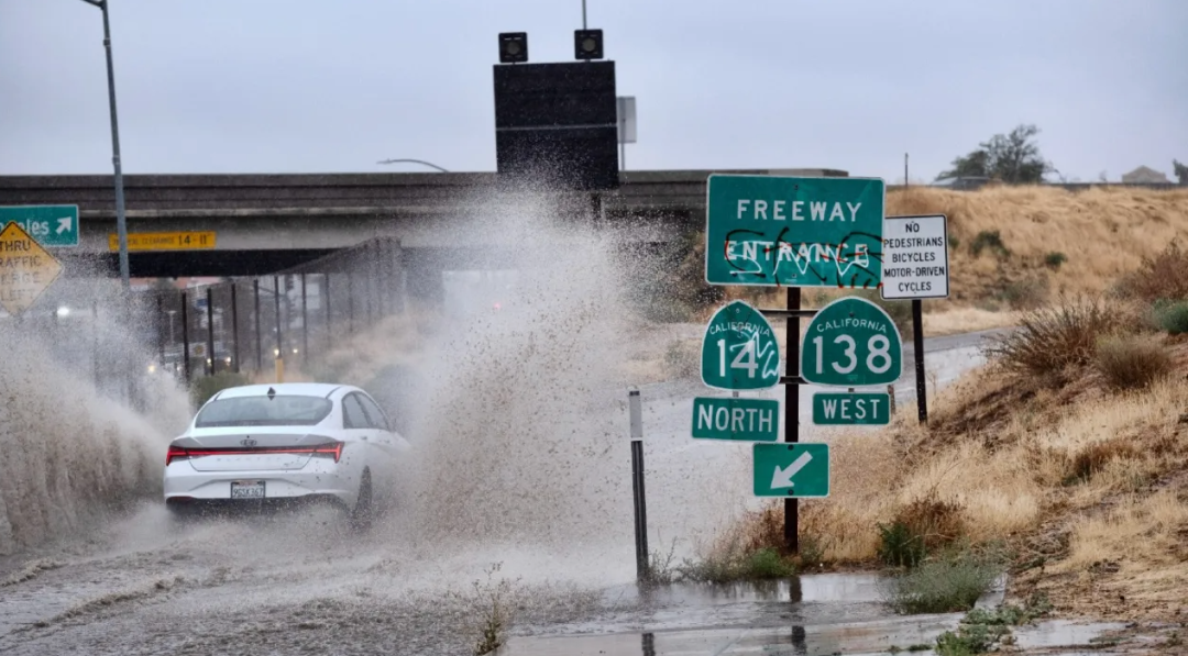
手机警报不停响,洛杉矶民众度过刺激的一天。

 图片来自thehill,版权属于原作者
希拉里周日打破多项纪录
84年来首次袭击洛杉矶的热带风暴带来创纪录的降雨量。
 图片来自twitter,版权属于原作者
洛杉矶国家气象局 (NWS)表示,希拉里打破了“几乎所有每日降雨量记录” 。
例如刘易斯牧场 (Lewis Ranch) 的降雨量为7.04英寸,帕姆代尔湖 (Lake Palmdale)为5.98英寸,加州大学洛杉矶分校为4.26英寸,千橡市为3.29英寸,而洛杉矶市中心为2.38英寸。

整个大LA范围内,降雨最多的地区为河滨县的Raywood Flats,达到10.55英寸。
 图片来自nbc,版权属于原作者
下面来看看您所在地区,昨日的降雨量如何:
Los Angeles County
Lewis Ranch: 7.04 inches
Leona Valley: 6.97 inches
Crystal Lake: 6.58 inches
Saugus: 6.45 inches
Cogswell Dam: 6.38 inches
Sawpit Dam: 6.22 inches
Big Pines Recreation Park: 6.18 inches
Aliso Canyon: 6.06 inches
Santa Anita Dam: 6.02 inches
Lake Palmdale: 5.98 inches
Mescal Smith: 5.81 inches
San Gabriel Dam: 5.67 inches
Mount Baldy: 5.66 inches
Valyermo: 5.65 inches
Newhall: 5.59 inches
Castaic Junction: 5.43 inches
Morris Dam: 5.41 inches
Big Dalton Dam: 5.35 inches
Del Valle: 5.24 inches
East Pasadena: 5.21 inches
Mill Creek: 5.11 inches
Chilao South: 5.00 inches
Inspiration Point: 4.69 inches
West Fork Heliport: 4.69 inches
Camp 9: 4.61 inches
Castaic: 4.49 inches
Stunt Ranch: 4.45 inches
Chilao: 4.29 inches
Eagle Rock Reservoir: 4.29 inches
Hollywood Reservoir: 4.29 inches
Poppy Park: 4.28 inches
UCLA: 4.26 inches
La Canada-Flintridge: 4.24 inches
Van Nuys: 4.20 inches
Sepulveda Canyon: 4.16 inches
Leo Carrillo State Beach: 4.10 inches
Avalon Airport: 4.04 inches
Tanbark: 4.04 inches
Monte Nido: 4.02 inches
Northridge: 4.00 inches
Palmdale: 3.94 inches
Warm Springs Camp: 3.93 inches
Claremont: 3.85 inches
Topanga: 3.77 inches
Warm Springs: 3.75 inches
Calabasas: 3.70 inches
La Verne: 3.70 inches
Whitaker Pear: 3.68 inches
San Rafael Hills: 3.66 inches
Agoura Hills: 3.65 inches
Sierra Madre: 3.51 inches
Burbank: 3.47 inches
Lechuza: 3.47 inches
Opids Camp: 3.31 inches
Porter Ranch: 3.31 inches
Hungry Valley: 3.30 inches
Saddleback Butte: 3.23 inches
Bel Air: 3.13 inches
Culver City: 3.01 inches
Canoga Park: 3.00 inches
San Antonio Dam: 2.92 inches
Alhambra: 2.84 inches
Santa Monica: 2.82 inches
Mount Olive High School: 2.79 inches
Chatsworth Reservoir: 2.52 inches
Beverly Hills: 2.51 inches
Catalina Island: 2.46 inches
Long Beach: 2.45 inches
Whittier: 2.40 inches
Downtown L.A.: 2.38 inches
Hansen Dam: 2.19 inches
LAX: 2.16 inches
Pasadena: 2.06 inches
Hawthorne: 2.01 inches
Orange County
Coto de Caza: 2.76 inches
Lower Silverado Canyon: 2.40 inches
Alameda Storm Channel: 2.29 inches
Brea Olinda: 2.20 inches
Yorba Reservoir: 2.20 inches
Pico Retarding Basin: 2.20 inches
Bell Canyon: 2.10 inches
San Juan Capistrano: 2.09 inches
Brea: 2.05 inches
Lower Oso Creek: 2.05 inches
Santa Ana Engineering: 2.00 inches
Carbon Canyon Dam: 1.98 inches
Fullerton Creek: 1.85 inches
Gilbert Retarding Basin: 1.85 inches
Laguna Niguel Park: 1.85 inches
Fullerton Dam: 1.83 inches
Garden Grove: 1.81 inches
Laguna Audubon: 1.81 inches
Orange County Reservoir: 1.81 inches
Wintersburg: 1.77 inches
Costa Mesa: 1.73 inches
Anaheim Hills: 1.65 inches
Yorba Park: 1.62 inches
Villa Park Dam: 1.61 inches
El Modena-Irvine: 1.61 inches
Lane Channel: 1.58 inches
Huntington Beach: 1.54 inches
Villa Park Reservoir: 1.50 inches
Peters Canyon Wash: 1.46 inches
John Wayne Airport: 1.36 inches
Corona Del Mar: 1.33 inches
Fullerton Airport: 1.02 inches
Inland Empire
Devore Fire Station: 3.40 inches
Cabazon: 3.28 inches
Temecula: 2.68 inches
Murrieta Creek: 2.44 inches
Norco: 2.32 inches
Chino Airport: 2.36 inches
Railroad Canyon Dam: 2.28 inches
North Elsinore: 2.20 inches
Portrero Canyon: 2.09 inches
Riverside South: 2.05 inches
Beaumont: 2.02 inches
Clark: 2.01 inches
Lake Matthews: 2.00 inches
March Air Reserve Base: 1.97 inches
Perris: 1.93 inches
Pigeon Pass Dam: 1.93 inches
Riverside Airport: 1.83 inches
San Jacinto North: 1.81 inches
Prado Dam: 1.79 inches
Moreno-Clark: 1.66 inches
French Valley Airport: 1.36 inches
Ventura County
Piru: 4.64 inches
Lake Piru: 4.17 inches
Cal State Channel Islands: 3.62 inches
Moorpark: 3.58 inches
Rocky Peak: 3.58 inches
Circle X Ranch: 3.50 inches
Deals Flat: 3.47 inches
Miller Ranch: 3.33 inches
Thousand Oaks: 3.29 inches
Simi Valley: 3.18 inches
South Mountain: 3.15 inches
Cheeseboro: 3.13 inches
Westlake Village: 3.10 inches
Last Chance: 3.03 inches
Santa Paula: 2.95 inches
Newbury Park: 2.82 inches
Lockwood Valley: 2.77 inches
Chuchupate: 2.56 inches
Saticoy: 2.20 inches
Sycamore Canyon: 2.09 inches
Nordhoff Ridge: 1.85 inches
Ortega Hill: 1.71 inches
Rose Valley: 1.69 inches
Oxnard: 1.57 inches
Apache Canyon: 1.38 inches
Ojai: 1.29 inches
Ventura: 1.04 inches
Santa Ana Mountains
Upper Silverado Canyon: 3.66 inches
Upper Harding Canyon: 3.66 inches
Santa Rosa Plateau: 3.56 inches
Horsethief/Rice Canyon: 3.54 inches
Santiago Peak: 3.07 inches
Leach/Dickey Canyon: 3.03 inches
El Cariso: 2.95 inches
Indian Canyon: 2.91 inches
McVicker Canyon: 2.87 inches
Holy Jim Canyon: 2.87 inches
Silverado Motorway: 2.64 inches
Modjeska Canyon: 2.32 inches
Sylvan Meadows: 1.97 inches
Fremont Canyon: 1.68 inches
San Bernardino and Riverside County Mountains
Raywood Flats: 10.55 inches
Mount San Jacinto: 9.91 inches
Heart Bar: 9.52 inches
Lytle Creek: 7.58 inches
Snow Creek: 7.40 inches
Bernina Drive: 6.72 inches
Wrightwood: 6.01 inches
Upper Tahquitz Creek: 5.95 inches
Mormon Rock: 5.77 inches
Heaps Peak: 5.13 inches
Morongo Valley: 5.08 inches
Converse: 3.88 inches
Pine Cove-Rocky Point: 3.07 inches
Fawnskin: 2.92 inches
Allandale: 2.91 inches
Big Bear Lake Dam: 2.87 inches
Big Bear Lake: 2.66 inches
Manzanita Flats: 2.53 inches
Vista Grande: 2.36 inches
Poppet Flat: 2.35 inches
Keenwild: 2.34 inches
Coachella Valley
Whitewater Trout Farm: 6.37 inches
Morongo Valley: 5.08 inches
Palm Desert: 3.72 inches
Wide Canyon Dam: 3.42 inches
Cathedral Canyon: 3.34 inches
Desert Hot Springs: 3.23 inches
Palm Springs Airport: 3.03 inches
Lower Tahquitz Creek: 2.75 inches
Cactus City: 2.60 inches
Thermal: 2.12 inches
Mecca: 2.01 inches
Thousand Palms: 1.50 inches
*以上数据来自国家气象局,截至周日晚上11:15
 图片来自weather.gov,版权属于原作者
此外,大家先别放松警惕。
雨虽然停了,洪水和泥石流却来了。
这场历史性风暴造成的持续损害。
 图片来自nytimes,版权属于原作者
风暴淹没了道路,倒塌了树木,并引发了南加州部分地区的泥石流。
 图片来自ktla,版权属于原作者
大雨将街道变成泥泞、碎片泛滥的河流。
 图片来自ktla,版权属于原作者
周一早上,在棕榈泉地区发现几辆车被困在泥里。
房车内的一名男子向直升机竖起大拇指,表示他情况还可以,等待救援中:
 图片来自ktla,版权属于原作者
无人机镜头显示,晚间111号高速公路沿线的企业和几个街区的居民区被水淹没:
 图片来自ktla,版权属于原作者
由于部分路段关闭,今天堵车可能更严重了。
 图片来自fox11,版权属于原作者
洛杉矶国家气象局敦促司机今天尽量不上路,即使是在雨停了的地区。
“虽然我所在的文图拉县目前可能没有下雨,但由于之前降雨的径流,许多道路仍然很危险。特别是在卡马里洛、千橡树、西米谷和菲尔莫尔,”洛杉矶NWS在推特表示。
 图片来自ktla,版权属于原作者
希拉里并不是过去24小时内袭击南加州的唯一威胁。
周日下午,奥海附近发生了5.1级地震,并有数十次余震。
 图片来自abc7,版权属于原作者
地震发生在下午2点41分左右。据美国地质勘探局称,其中心位于奥海东南约四英里处,十几次余震中,至少有六次余震超过3.0级。
目前还没有人员伤亡或财产损失的立即报告。

但据社交媒体用户称,包括华人区在内的大洛杉矶地区都有震感。
地震发生时,热带风暴希拉里正在给南加州带来大雨,令居民感到不安。
科学家们很快表示,希拉里与地震之间没有联系。

地震学家露西·琼斯博士表示,此次地震与恶劣天气无关。这是自1932年以来第一次在文图拉盆地内遭遇5级地震,这种情况并不常见。
目前,发生较大地震的可能性仅为5%,大家不必过于恐慌。
“希拉里”到访南加,段子网上走红
不夸张的说,昨天,全南加人都在“等风来”。
相信不少华人朋友都被这个图刷屏,网友太有才了:

图片来自网络,版权属于原作者
大雨晚上下,白天的南加人都在干啥呢?

来看看这些南加“显眼包”吧

加州人加州魂,飓风晚上来,先去浪一浪🏄🏻:
正当大家被窝看Netflix吃缺德舅速食之际,有LA妹子风雨无阻锻炼中🏃🏻♀️:

难得下雨,加州老爸决定去路上洗个澡:

再来免费洗洗车吧:

看完是不是感觉这两天紧绷的心情一下放松了。
不知道大家对“希拉里”有啥感想,欢迎留言哦。
本文由北美省钱快报小编整理,内容来自dailymail等媒体,不代表本公众号立场,图片来自网络,版权属于原作者,未经许可不得擅自转载,否则将追究责任。
撰稿:Yu
或填写:
https://www.dealmoon.com/cn/comments/adcooperation
或扫👇二维码,填写表格


终于要熬过去了,出门注意路况👇
蓝字→ 点击右上角“...”,点选“设为星标🌟”,不错过任何精彩!
图片来自thehill,版权属于原作者
图片来自twitter,版权属于原作者
图片来自nbc,版权属于原作者
图片来自weather.gov,版权属于原作者
图片来自nytimes,版权属于原作者
图片来自ktla,版权属于原作者
图片来自ktla,版权属于原作者
图片来自ktla,版权属于原作者
图片来自ktla,版权属于原作者
图片来自fox11,版权属于原作者
图片来自ktla,版权属于原作者
图片来自abc7,版权属于原作者
